Nighttime Lights in Ukraine
March, 2022
Every night at about 1:30 AM local time, the Suomi NPP satellite passes overhead, no matter where you are in the world. Onboard is the VIIRS sensor, which is mostly used for environmental sensing. However, during these nighttime flyovers, it takes high-resolution pictures of the lights emitted by humans from street lights, houses, car headlights, etc.
During the Blitz, civilians were instructed to turn off their lights at night to make it harder for bombers to target their houses in the darkness, and it seems that modern technology hasn't made this strategy entirely obsolete. Moreover, if lights are off in city centers because businesses are closed, or if power is unreliable, or if people are keeping off the streets, you would expect less light to be emitted.
This video shows images of Kyiv captured by VIIRS from the beginning of February through late March 2022. There are lots of clouds, and light from the Moon causes some images to be much brighter than others, but there is a clear drop in light from the city around February 24th, the day the invasion of Ukraine began:
After the invasion begins, you can see flickering lights to the north of Kyiv. These lights appear elsewhere in Ukraine, and seem to approximately line up with the locations of fighting. My best guess is that they are fires caused by the fighting, or they are military camps and vehicles.
The major roads running out of Kyiv to the west also go dark around the 26th. That was the day that Ukrainian forces blew up the bridges to Kyiv to make it harder for the Russians to advance.
Kyiv wasn't the only place that got darker. The map below shows the changes in nighttime lights across Eastern Europe, with the Ukrainian border faintly highlighted. The average brightness (corrected for lunar effects, clouds, etc.) from February 1st through February 24th is shown in the red channel, and the average brightness from February 25th through March 18th is shown in the green and blue channels. That means red places got darker since the invasion, cyan places got brighter, and white places stayed the same.
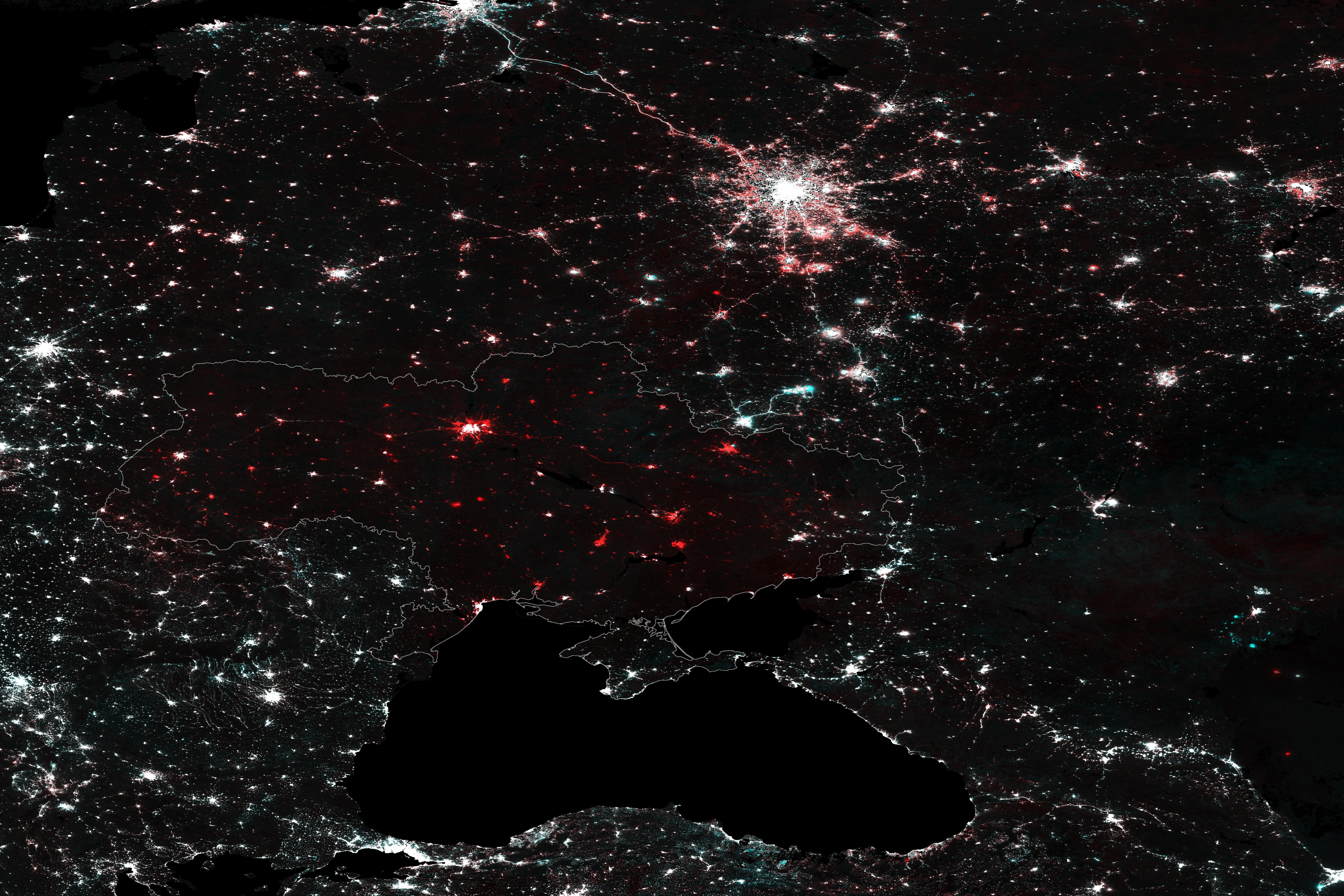
In contrast to its neighbors, all of Ukraine, from the cities to the countryside, got darker over this period. That includes cities in the far west, away from most of the areas that have seen on-the-ground fighting. The only exceptions are Crimea and parts of the Donbas which have been under Russian occupation since before the 2022 conflict.
Below is a labeled and interactive version of the map above:
These maps were generated using data from NASA's Black Marble. In particular, the VNP46 data suite, which was downloaded from the Level-1 and Atmosphere Archive & Distribution System (LAADS) Distributed Active Archive Center (DAAC) at the Goddard Space Flight Center.
If you want to explore yourself, I recommend using NASA Worldview which provides a nice interface for browsing the unprocessed VNP461 data. For the processed data (which you need to use for anything more than visual inspection), you have to download VNP462 from LAADS DAAC.